Brief on Water Sharing (Trans-Bordering Rivers)
Brief on Water Sharing (Trans-Bordering Rivers)

Engr. Dr. Md. Anwar Hossain
There is seldom available a country not facing problems with either domestically or continentally. The country suffering from massive flood, yet facing huge crisis for draught etc. Water is the God gifted natural asset flowing both nationally as well as globally. In anyway, is it so critical to address, certainly not. With careful and intelligent approach, we easily can overcome water problem created naturally and maximum artificially. There are the countries having no rivers but they solved the problems by themselves sometimes only with highly saline sea water. These are sustainable and independent solution.
While in the case of our country, the problem is appeared and projected as to be a great problem even it is not a problem. We made and took it a problem. We do not have any shortage of water. The annual surface flow of water through the country is incredibly huge that if we hold it, the whole country would be 30 feet underwater throughout the year. Why then we suffer from water crisis? It is so natural that our thinking is so funny, why the flowing water does not stay in the river by itself. We always remain in a state of shouldering out responsibility to others and make us free of criticism, all nuisances are with India and we do not try even.
The problem what we see as an acute one but not, it is easy, sustainable and eco-friendly and very well within our capability both financially and technologically. The way water problem is projected as to be incredible, exactly in the same and in the better way it is easy and feasible.
Our sincerity is the essence to bring success nationally as well as globally and may create environment for universal brotherhood to follow a splendid ending.
About underground water, the level goes down and down each &every year, since rate extraction is higher than that of precipitation. But lagging of water level can be replenished by artificial recharging of surface water. From where water is extracted, water can also be poured in the same level.
The article clearly tells how to develop a knowhow for overcoming water crisis problem nationally and globally, maintaining a sustainable eco-friendly natural environment.
-
The Landmark Water Law
The Landmark water LAW recognizes that river channels and streams possess a right to flow, a right to avoid harmful alterations to ecosystem and biodiversity, a right to be free from contamination and a right to rescue and rehabilitate important water zones among others.
1. Helsinki Declaration, 1992
“The convention provides a legal framework within which two or more parties may co-operate to “prevent and control water pollution across National frontiers, ensure the reasonable and impartial use of trans-bordering water”.
2. Berlin’s Rules and Helsinki Rules
“Helsinki Rules and UN convention establishes and emphasizes the right of each riparian state to a reasonable and equitable share, while The Berlin Rules emphasizes the Obligation to manage the shared water courses in an equitable and reasonable manner”.
But no declaration had ever described, “What is reasonable and equitable share or manners, and on breach of such obligation of shared water courses, what is the obligation of the International Community to address them”. No remedy to make the countries in default obligatory to follow the rules.
-
Indo– Pakistan Water Sharing
India stopped flow of water of the RAVI and ERAWATI rivers completely. According to the agreement between India and Pakistan in the presence of UN officials in 1960, India holds 100% of water of these rivers. Besides this India holds 100% right of waters of river SHATONDRA, SHOTOSHATEE, BIPASHA.
India did not stop the water flow before, because of the KASHMIR CRISIS. Now it is over. India reacted now. Pakistan holds the right only on INDUS, JHEELAM and CHENOR. Pakistan has the mighty River INDUS originated from The Himalayas runs through North to South in the middle line of PAKISTAN.
Pakistan constructed at least 18 Dams/ Barrages on The Indus and its tributaries and solved the water crisis problems sustainably. (Fig; above).
-
Indo-Bangladesh Water Sharing
The same case, even the worst may happen with Bangladesh. Bangladesh shall not get a single drop water in the near future. Bangladesh does have all rivers originated from India and Myanmar (54 from India and 3 from Myanmar). Bangladesh is to rely upon the good will water sharing from these countries. However; Good-Will sharing would no longer continue. The indication is already prominent meanwhile.
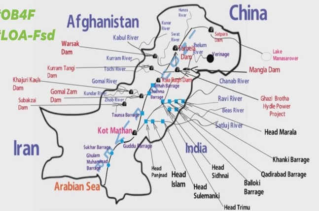
It is very important and pertinent for the country to find out The Sustainable Solution to meet the devastating and lifesaving challenges related to water flow, may it naturally or artificially have created. Relying on India for anything related to water sharing is mere an expectation rather than a reality.
Bangladesh receives 93% water from India and only 7% water from rainfall. This is the actual scenario and Bangladesh is to prepare herself for the periods when it shall likely to receive 00% water from India (During Dry Season). Denying water sharing is already in exercise. Keeping these conditions in the primary and active consideration, Bangladesh is to formulate planning for a sustainable solution to the dangerous, almost artificially, created disasters.
-
CM, Momota Banerjee
Recently, in an interview with INDIA TRIBUNE, CM of West Bengal, Mrs. MOMOTA BANARJEE said “We will be left with no water to drink, if we share Teesta Water with Bangladesh. Do not judge the rivers by the summer potentials, by seeing the Monsoon situations, she cautioned”.
CM also claimed that after Bangladesh and China set up a DAM on the river ATRAYEE, the River dried up in West Bengal. The river flows through Dinajpur District states”.
-
River Atrayee
Atrayee originates from SILIGURI, went 40 KM after flowing to Dinajpur Dist. of Bangladesh, it enters again in India passes through Kumar Ganj and Balaghat in Dakkhin Dinajpur district.
The river then re-enters Bangladesh. It splits into two rivers; Gabura and KANKA and then flows into CHALAN BEEL. Total Length is 390 KM.
So, we can easily draw a conclusion on how much we can expect from India regarding water sharing. It is clear. However; it is sure, “Almost in every year, in the rainy season the country is most likely to suffer from over-flood and in the dry season from draught.
-
Flow of Surface Water
Surface Water is made up of rivers, streams, lakes, Beels, Haors, baors, canals, Banners, Dhigee and ponds. In other words, all waters on the surface of the earth including fresh and saltwater are surface water. In Bangladesh rainfall and Trans-bordering- river flows, are the main and the only sources of surface water. However; we have vast water underground without any bordering limitation.
Bangladesh has an average annual surface flow of water about 1,073-million-acre feet (1MAF=43560 Cusec), of which about 93% (870 MAF) are received from India as inflow and rest 7% (203 MAF) as rainfall.
This water, 1,073-million-acre feet, is equivalent enough to cover the entire country to a depth of 9.14m (30 Feet).
About 12% of total water (1,073-million-acre feet) is lost in evaporation (Irrigation and Other uses etc) and the rest 88% of water, flows to the Bay of Bengal.
We have so much water, yet we are crying for water and suffering from draught almost every year and blaming others continuously. We are making others guilty of non-cooperating in sharing water of International Rivers. However; the neighboring attitude on water sharing is no longer positive.
We are just trying to escape our responsibility by holding others to be guilty of fault. This is not a solution but an escaping tendency. There are many countries who do not have any river. What they do to meet their water requirement. They are not blaming others but established a sustainable solution. Nobody shall come forward to write our destiny, our future. It is we who is to find a sustainable solution and it is very well possible and easy.
We have a total of 54+3 rivers (54, originating from India and 3 rivers from Myanmar) and 700 to 900 rivers including tributaries and distributaries crisscrossed, connected by Khals and Nullahs. Besides these there are more 69 Trans bordering-rivers but remain unrecognized.
We have 25000 KM of streams or water channels, 13 Lakh Ponds, more than 10000 Haors/baors/Beels/Banurs etc. The average depth of the rivers is 10 feet to 30 feet and width is 100 M to 500M.
-
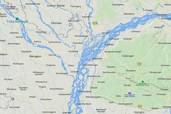
Tista Barrage
Tista River: Total Length-415 KM, 300KM inside India and 115 KM inside B/desh.
B/desh Tista barrage is at DALIA, some 17 KM inside B/desh Border while GAJOLDOBA barrage is 60 KM inside India. Only 77 Km River is at front.
- From Chilmary-Fulsory Ghat to GAJOLDOBA Barrage of India–total length available ahead for B/desh is almost 200KM if the Tista Barrage would be constructed at Chilmary-Fulsory Ghat.
- Inside India at upstream of GOJOLDOBA, there are 13 DAMS over Tista River in the last 30 years and are used to generate power during the rainy season and for Irrigation during the dry season, blocking the river’s flow.
-
The Solution Available
The best and the sustainable solution available to us as;
- We can do the same thing in a better way. By intelligent use of water resources in a natural way, we can overcome the water crisis problems for ever.
- B/desh is a plain country having very minimum sea level difference, only 4-to-10- meters between high and low areas. It is a blessing for us.
- Every year we have Rainy seasons with surplus flow of surface water (1073 million acre-feet flow) while Dry seasons with no flow.
- By introducing Dam or Barrage technology intelligently, we can preserve enough water in our rivers, canals, Beels, Haors etc for our dry season. We can successfully overcome the problems of water crisis.
- Dry season is only for 3 to 4 months. Not only that, by preserving waters in our rivers etc, our groundwater shall be replenished naturally. Only 12% water would be lost, 88% water is to remain in the rivers etc. Throughout the whole year the rivers would remain full of water. Natural system shall prevail.
- It is seen that there is no question on ground water level usually raised during rainy season, because huge surface area of water results sufficient precipitation.
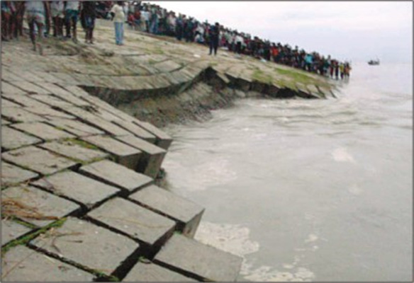
By introducing Dams/Barrages, we can substantially reduce the proneness of River-Bank erosion. Not only that, a river full of water does not undergo erosion as well as successfully prevents the sudden thrust of water from up-streams during flood.
10 How to Control River current
If we have Dams/ Barrages in our rivers, we can control the flow of current at our Will. If there is possibility of erosion, by closing the doors and controlling water current we can easily prevent the erosion. In the case 0f floods all gates including spillway, if any shall remain wide open. Once the waters come down to the rivers, by closing the doors successively and controlling current river bed and bank erosion can be prevented. The Dams/ Barrages are recommended to construct over the wider part of the river with a view to maintain average natural flow constant. Our tendency is to construct over the narrower part of the river. It highly discouraged rather prohibited. This is applicable also for bridge construction. The dams/Barrages may be used as multi-purpose solution.
-
Dhaka-Aricha
Every year we always experience that there is no flow in the rivers throughout Bangladesh during the dry season. The water level height is same and equal to that of The Bay of Bengal. At the mouth of the river MEGHNA, I did visit and by myself saw the GREEN GRASS over the water. So high is the ground elevation. It is a blessing in disguise, if not the last drop of water would flow to the sea.
-
Interesting Challenge
However; the water depth from Dhaka to Southern districts, including Aricha to Chandpur is sufficient for Inland Navigation, water depth varies from 30 to 50 feet. Whereas the conditions in the North and NW rivers are otherwise different, no/minimum navigation is possible, due to very shallow water depth and what we can easily overcome by using intermittent Dams/ Barrages on these rivers.
-
Tista Barrage at DALIA
TISTA barrage at Dalia is 17 Km inside Bangladesh and GAJOLDOBA barrage is 60 Km inside India. 77 Km is ahead of DALIA and CHILMARY is 120 Km behind DALIA. Sea level height of GAJOLDOBA is 67M and that of TISTA is 32M.
- Dalia and Chilmary- sea level height is almost same 32M, while Sea level height of GAJOLDOBA is 67M.
- Let us consider as an example, the Tista barrage at Chilmary, we may have 190 KM ahead up to GAJOLDOBA to preserve water instead of 77 KM but construction cost would be the same. Why did we construct the barrage in Dalia but not in Chilmary, a question of inquisition, whether this is wrong or indifference?
- Constructing The Tista Barrage at Dalia is an emotional decision. With the same cost the Barrage if at Chilmary, it would have about 200 Km ahead as a water reservoir and without any problem; 10 times more benefit could be achieved with minimum modifications.
However; this is not a loss and can easily be used in our favors. We would have another barrage at Chilmary; the existing one would augment its strength by sharing the water head. Let us construct the 2nd Dam/Barrage at Chilmary. May it be a Pilot Project.
-
Similarly, we can have barrages
If we go through the geographical map of Bangladesh, we can easily build Dams/Barrages as applicable on the rivers as follows [Fig.] bellow.
- Jamunesshary near Nagor Bari. The river is sufficiently longer than TISTA
- Padma at Goalonda.
- Modhumotee, Kobutakkha, Bhairab at Khulna.
- Brahmaputra at Bhairab.
- Sheetal Lakkha at Narayangonj.
- Kushiyara and Surma at Bhairab.
- Dakatia at Chandpur.
- More importantly, if we have a big barrage over River Meghna at or near Bhola, we can have almost a single solution to the problem. All other Dams/Barrages ahead shall augment the strength individually by themselves and reduce the risks involved there.
- The careful selection of the best site is a matter of detailed reconnaissance only.
- The barrage doors are to be closed during the month of September or October for preservation of water and to be wide open during the rainy season and on requirement. Some impediments would be for inland water transports systems.
-
Water Logging
It is beyond my imagination that for mere heavy rain, our COASTAL CITY COX’s BAZAR goes 2-3 feet underwater, while the mighty BAY OF BENGAL is at the root of the city, only a few drains are sufficient to drain out and prevent water logging. What an efficient planner we are! Who is looking after the city, who is carrying out development projects. The scenario is the same for other mega cities also like Chittagong or Dhaka but why, I do not have any understanding. This is nothing but only surveying and reconnaissance problems.
That reminds me how indifferent we are in planning, designing, constructing, surveying and calculating. The engineers and the approving authority must be courageous to accept the mistakes and responsibility for the failures. The time has come to rethink the so-called achievements with wide open heart with a detailed engineering mindset.
-
Bridge Construction
It is not only a surprise but a matter of insult that
- If we build bridges, the rivers dry up but the British did it about 140 yrs back, no river dries up, why then we did not follow the existing well proof British design rather we change the design and bring hazards. If our design does not prove to be advanced and risk-free added longevity, why did we change the design and brought hazardous risk, uncertainty to natural and human lives and more so involved a huge cost?
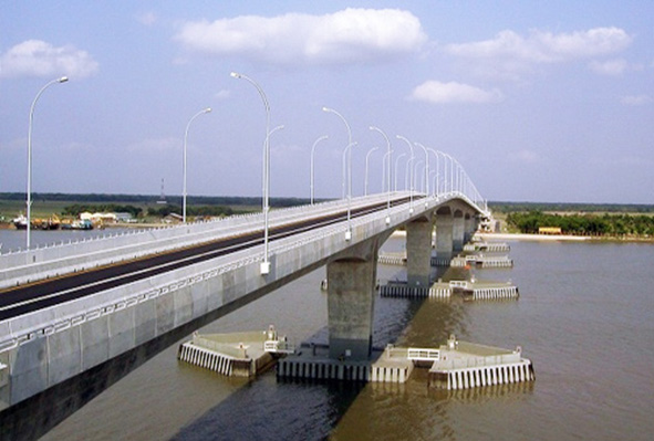
- Example, Hardinge Railway Bridge, Gorashal and or Bhairab Railway Bridge, already covered 140 yrs. No river training did except guide bund. The Pile caps are oval/elliptical.
- Standing on the same platform after 140 yrs, expected life of our Road Bridges (Jamuna, Padma) is set to 100 yrs and changed the design. The Pile caps are Hexagonal/Rectangular. (Fig.)
- The rivers dry up in the dry/ winter season. We have to think twice whether River Training is wiser solution or not, shall it be a risk for the life of the bridge and or the banks and surroundings. I think river training if not compulsory shall be avoided and may be considered detrimental for future of the river, risky for bridges and in turn risks the future of the country. Never to compromise with the plea of reducing costs. It is already proved in the case of Padma and Jamuna bridges.
-
Railway bridges and Euler’s Equation
Hardinge and other railway bridges- pile caps are Oval/ Elliptical shape. ∞Padma and Jamuna bridges pile caps are Hexagonal/ Rectangular and does not satisfy the basic Euler’s Eqn (dP/dR ∞ v2/R) that causes dP/dR=0 since R ∞ tends to infinity (For Hexagonal straight edge R tends to infinity) and the Ferry hits the pillars, no outward pressure difference is there. For a straight or hexagonal pile cap, R-radius is infinity, meaning dP/dR=0. The captain of the Ferry is held responsible and threatened to be sacked.
Rupsha Bridge has an oval pile cap but slotted. (Fig.)
In the case of Pile caps of oval shape, R has a value and dP/dR, pressure difference is there, no water craft did hit the pillar so far. Nothing such happened with Railway bridges for 140 yrs where the pile caps are oval/ elliptical, no river training works done except the guide bund. (Fig.)
Longevity of bridges with oval pile caps shall be more than double than that of straight or hexagonal caps.
-
Sirajganj Hardpoint
They are the designers who with collaboration with HYUNDAI Coy of KOREA did address for only 2.5 Km SIRAJGANJ HARDPOINT at a cost of 332 CRORE Taka and life guarantee was 100 yrs, but washed away within 24 yrs only of construction. The same designers are engaging themselves in MARINE DRIVE and shore protection works in Cox’s Bazar. The solution offered by them is a great risk for the natural behavior of the sea and the related eco-system. But there is a solution, maintaining natural behavior of the beach, the land and the eco-system. R&H did find the feasibility of the solution and forwarded the request to Marine-drive maintenance Authority.
-
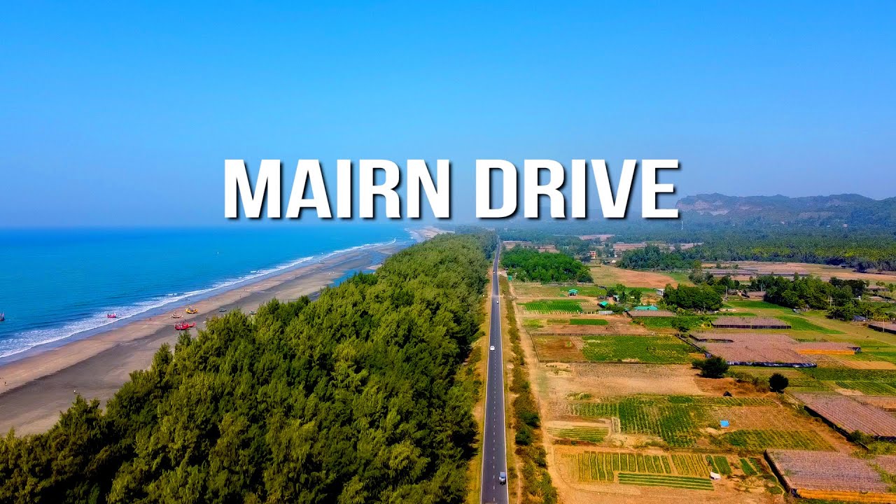
Marine Drive
The Marine Drive shore line and the shore line in the BEZA area very recently have undergone erosion and washed away by Full-Moon high tides. These are now under active consideration of protection by addressing measures in a way, which may be detrimental to the SEA as well as to LAND. More importantly, these are the works/designs done by the same who miserably failed before. They have offered multiple options (13 Options) to a single solution. The previous solution was also given by them and grossly failed.
-
Cox’s Bazar Beach development
A Mega Development project for improving Cox’s Bazar Seashore (কক্স বাজার মহাপরিকল্পনা) is under consideration, the same mistake is most likely to take place. We have to be very careful not to disturb the natural behavior of the Land and the Sea.
-
About Flooding
Recent flooding in the Comilla, Noakhali area, we complain on communication absentees. We can collect the information of cyclones from a distance of thousands Km, but Cherrapunji or Sikkim is at a lesser distance. The collapse of the Dam at Sikkim was already known to us, the water is to flow no other way than Bangladesh. Environment Ministry, SPARSO and WB did what. They had been in threat of losing their service, status, afraid of being apprehended/attacked etc and hidden themselves during the period of turmoil. They had not been serious in these important issues.
DUMBUR Barrage is a Hydroelectric Dam with hardly 5-Megawatt capacity at peak. If it collapsed, the water discharged would not be so much to create flooding downstream.
However; for a pretty long period of time, the region does not suffer from flood, meanwhile indiscriminate construction of roads, culverts or bridges etc without detail reconnaissance throughout the area may somehow be responsible for flooding. The Mithamoin Iconic Road is a real example of Sunamganj flood.
-
Recharging of Ground Water
It becomes alarming to know the news available in the media that the under-ground water level of Dhaka city is dangerously going down and down each and every year. This is because rate of extraction is more than the rate of natural recharging. But why, “The way we extract water in the same way surface water can be recharged, requirement is to make the water free of pollution”. Moreover, we can increase the permeability of soil. Spreading the water over a large surface area by way of irrigation which allow a portion to evaporate and the larger portion to penetrate the soil to meet the water under-ground. The more the surface area, the more is the water to penetrate naturally and replenish underground water. That’s the case in rainy season, the water surface is wider enough.
-
Pollution Free Management of Plastic and Polythene
Polythene is the trade name of polyethylene which is otherwise a plastic material. Polythene is a water proof plastic film manufactured from petroleum products. Indiscriminate use of Plastic and polythene objectionably creates hazards for environment. We must get rid of such hazards asp. It is better to go for Chemical recycling process of plastic products. This is Pyrolysis process and Catalytic degradation and gasification. Pyrolysis is called Hydrothermal Process. Polythene placed in a reactor filled with water, heating to a temperature of 400-to-500-degree centigrade. At this high temperature and pressure water breaks down the plastic materials and converts them in to oil. Most plastics are originally made from oil. So the process backs the plastics to oil again.
-
Conclusion
As a pilot project we can immediately go for constructing the 2nd Tista barrage at Chilmary area and confirm the feasibility. Beside the above approaches we may think for the followings:
- In city no building should be with ground floor closed. No individual surrounding security wall house wise but community/ regional capsule peripheral wall shall be there.
- Detail house building policy for rural areas.
- All roads to have culverts at best 200m interval.
- Waste water/ kitchen waste management plant.
- Use of Haors, baors, beel, Banner etc during rainy season for vegetable production. Design is there.
- Measures to prevent river erosion sustainably.
- Prevention of indiscriminate use of natural resources.
- Traffic discipline. (Save pol and reduce pollution).
- Pollution free brick fields and brick substitute.
- Palm oil cultivation along the line of railway road.
- Economic and perfect use of Kaptai Lake.
- Kaptai Hydraulic Power plant at 50 km off Cht, let there be the 2nd Plant at 10 km off Chittagong.
